Cozumel International Airport (CZM)
Orientation and Maps
(Cozumel, Mexico)
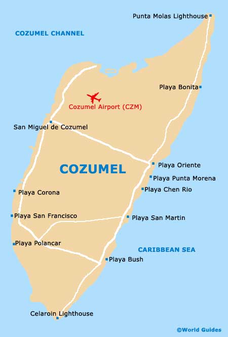
Situated approximately 70 km / 43 miles to the south of Cancún, Cozumel is actually the only true Caribbean island in the whole of the country. Many people visiting Mexico choose to fly to the island, with Cozumel International Airport (CZM) located minutes away from the main resort of San Miguel.
Locally known as the 'Island of the Swallows', Cozumel is close to the eastern shoreline of the Mexican Yucatán Peninsula and is perhaps best known for its spectacular waters and coral reefs, which are particularly appealing to divers.
Cozumel International Airport (CZM) Maps: Important City Districts
The island of Cozumel measures around 53 km / 33 miles in length and 14 km / 9 miles in width. San Miguel has a population of almost 100,000 and lies on the western side, next to the coastline, with the Avenida Rafael Melgar stretching along the waterfront. Close to the harbour you will find the main plaza, around which are plenty of places to relax and dine out.
Beaches are particularly plentiful along the coastline of Cozumel, especially on the eastern side of the island. However, swimming on the east coast can be dangerous at times, due to the unpredictable riptides. Playa Palancar is amongst the most popular beaches and lies approximately 16 km / 10 miles to the south of San Miguel. At the very southern tip of Cozumel you will find the Parque Punta Sur, with lagoons, crocodiles and a host of migrating birds.
Mexico Map

Cozumel Map